Powered By Blogger

Wednesday, 14 January 2015

AirAsia’s second black box retrieved


Divers on Tuesday retrieved the cockpit voice recorder and may have located the fuselage of the crashed AirAsia jet in the Java Sea as experts will now use data from the two crucial black box devices to determine the sequence of events that brought the flight down, The Times of India reports.

The cockpit voice recorder, that possesses the last two hours of conversation between the pilots and with air traffic controllers, was found close to where the flight data recorder was recovered from the bottom of the choppy waters on Monday.

It was freed from beneath the heavy ruins of a wing early in the morning from a depth of about 30 metres, said Tonny Budiono, sea navigation director at Indonesia’s transportation ministry.

This comes as a major potential breakthrough to solve the mystery of the Airbus A320-200’s fatal crash on December 28 that killed all 162 people on board, after days of multi-national efforts to scour the seabed were hampered by bad weather.

Divers took advantage of calmer mornings yesterday and today to retrieve the black box — designed to survive extreme heat and pressure — usually inside the tail section but found missing from the wreckage when it was pulled out.

Earlier, an official said the cockpit voice recorder — part of two recorders that make up the black box — was on an Indonesian navy ship and will be flown to Jakarta to be downloaded and analysed with the flight data recorder.

“This is good news for investigators to reveal the cause of the plane crash,” said Tonny Budiono, sea navigation director at the transportation ministry.

“Today we have completed searching for the main things that we have been looking for,” Rear Admiral Widodo, the commander of the navy’s western fleet, told reporters.

“But the team will still try to find the body of the plane in case there are still bodies inside,” he said.

Only 48 bodies, including at least two strapped to their seats, have been found in the choppy waters so far despite over two weeks of search operations.

The black box recorders, which are actually orange, are expected to shed new light on the mysterious crash that claimed all 162 lives on board the ill-fated AirAsia Flight QZ8501, en route from Indonesia’s Surabaya city to Singapore.

Investigators may need up to a month to get a complete reading of the data to determine what caused the AirAsia group’s first fatal accident half way into a two-hour flight.

Since the device records in a two-hour loop, all discussions between the captain and co-pilot should be available.

In another crucial development on Tuesday, divers may have found one of the plane’s engines that has a control unit to record data about performance, said Nurcahyo Utomo from the transport committee.

“If something is wrong with the engine, or weird, it will be recorded,” he said.

The suspected location of the Airbus A320-200 engine could not be immediately confirmed, Channel NewsAsia reported, citing an investigator.

Search teams have also possibly identified the locations of the plane’s main fuselage and stabiliser, with divers reported to have marked out the spot the fuselage is believed to lie, 30 metres deep, the report said.

Search and rescue agency coordinator S B Supriyadi said the fuselage is believed to have been found northeast of where the tail section was previously spotted by a ship scanning for wreckage, CNN reported.

The discovery of the fuselage would be a significant development, as officials believe it contains the remaining bodies of victims.

Officials on Monday gave new dramatic details of the accident, with Supriyadi saying an initial analysis of the wreckage recovered so far indicated the plane exploded on impact with the water due to a rapid change in pressure.

Meanwhile, chief of Indonesia’s search and rescue agency BASARNAS Fransiskus Bambang Soelistyo on Tuesday said the legal timeframe for retrieving bodies is seven days.

Though focus of the operation shifted on the 11th day when the black box was found, the search for bodies continued, he told a parliamentary hearing in Jakarta.

“Our main task is to find the victims. “Even if both black boxes are found, it doesn’t mean that our operation is over,” he told reporters before heading to Surabaya to meet the victims’ families.

He said BASARNAS was focused on finding the bodies while the armed forces were focused on finding the fuselage, that officials initially believed to contain the remaining bodies. However, all 48 bodies recovered so far were found spread out in the sea.

Soelistyo promised families that he will try his best to find all the passengers that were on board the AirAsia flight.

Meanwhile, the airline’s flamboyant boss Tony Fernandes issued a message to customers, saying “the past few weeks have been the most difficult weeks of my life since starting AirAsia 13 years ago”.

Reducing risk of stroke and heart attack


One of the best ways to protect yourself against a stroke or heart attack is by not smoking. Here are other ways:
Maintain a healthy weight: Being overweight increases your risk of high blood pressure, high cholesterol levels, cardiovascular disease and diabetes – risk factors for a stroke and heart attack. So eat a nutritious diet and aim for 30 to 60 minutes of physical activity on most days.
Limit fats and cholesterol: Limit meat to a total of 6 ounces daily. Choose fat-free or low-fat dairy products. Limit saturated fats and avoid trans fats. Instead of solid fats (butter, margarine, shortening), use monounsaturated oils (canola, olive and peanut) and polyunsaturated oils (corn, safflower, sesame, sunflower and soy).
Eat fish that have omega-3s; Eat fish that have omega-3 fatty acids, such as salmon and trout.
Eat plenty of fruits and vegetables: Produce contains nutrients such as potassium, folate and antioxidants that may protect against stroke and heart attack. Eat at least three servings of fruits and at least four servings of vegetables daily.
Use alcohol moderately, if at all: Too much alcohol can raise blood pressure. Moderate drinking is defined as no more than one drink a day for women and anyone age 65 or older and no more than two drinks a day for men under 65.
Reduce sodium (salt): Limiting sodium in your diet and making other lifestyle changes can help prevent high blood pressure. If you already have it, reducing sodium intake further may help lower it.
Source: mayoclinic.com

Tuesday, 13 January 2015

How to sleep well


If you must take sleeping pills, make sure they are taken only temporarily and are a stop-gap measure. The best thing to do is to find out what is causing your sleepless nights and get wholesome solutions for it.

Treating a drug’s side effect with another drug can start a vicious cycle of drug side effects and interactions that can land you in the hospital or even kill you. They create more problems than they solve, sometimes with life-threatening consequences. Remember the sad case of Heath Ledger, the young and very promising actor in the film “The Dark Knight.” Heath apparently had problems sleeping. He claimed he could not sleep for more than two hours at a time. He began to take many sleeping pills and is rumored to have died taking an overdose of a combination of prescription and over-the-counter sleeping pills.

Other commonsense causes of insomnia

The causes of our insomnia are usually sitting right in front of us, in plain view. Here are some of the most common culprits.

Caffeine: Caffeine is, without doubt, the number one cause of insomnia, especially with those of you who can’t resist an afternoon cappuccino. You may not realise that many soft drinks have caffeine in them. The same goes for many energy drinks. Most soft drinks are loaded with caffeine. Try holding off on the caffeine after the noon time for a few weeks, and see what happens. Again, if you find that you are one of the people who is affected by the caffeine in soft drinks, don’t take them after 4pm.

Some people cannot even take decaffeinated coffee in the morning without having sleepless nights! I am one of those. After keeping off both coffee and tea for some time, I tried taking decaffeinated coffee with Coffee Mate. I couldn’t resist the creamy taste. I found I couldn’t sleep. Once I left the coffee, I slept better. I now drink only herbal teas.

Diet and “energy” pills and supplements often contain caffeine, ephedra, amino acids and other stimulants that can keep you awake at night.

Too much alcohol: A glass of wine with dinner can be relaxing, but too much alcohol will keep you tossing and turning. You may fall asleep but wake up after a few hours and will be unable to sleep again.

Sedentary lifestyle: Couch potatoes often find themselves clutching the remote control into the wee hours. Exercise is one of the best sleep remedies I know of. A brisk 20-minute walk or any type of enjoyable exercise (preferably outdoors) sometime before 9p.m. can be just the ticket. Exercise is also a good remedy for stress-induced tension, which can leave you lying awake worrying instead of sleeping.

Enlarged prostate: Older men with benign prostate hypertrophy or BPH who have to get up many times during the night can often get relief with a Saw Palmetto supplement combined with zinc and selenium (follow directions on the container). If that doesn’t do the job, try a pea-sized dab of progesterone cream every day, using a progesterone cream that contains 450mg to 500mg of progesterone per ounce. I am told that most men over the age of 65 can benefit from a little bit of progesterone cream.

What about melatonin? Melatonin is a hormone secreted by the pineal gland in the brain in response to darkness. Its message to the body is, “Time for sleep.” As we age, we produce less and less melatonin, and this may be a primary cause of the sleep problems so common among older people. Sleep in complete darkness to enhance your production of melatonin. Get curtains that will completely block out the street and other neighbourhood lights.

Also, get masking tape to cover night lights on electrical gadgets in your room or get the electrician to remove these lights.

If you’re past middle age and you have incorporated these commonsense sleep aids and you are still not getting enough sleep, you can try taking a melatonin supplement an hour before bed. You don’t need much melatonin to have an effect — anywhere from 0.5 to 5mg is plenty. If melatonin deficiency is your problem, you may sleep better the first night you take it. But do not take melatonin supplements if you are not ready to rest.

Melatonin will make you sleepy and encourage your body to fall asleep. Take it one hour or so before you plan to go to sleep and never before driving or operating machinery. You should also make sure you have plenty of time to sleep while the melatonin is in your system.

Again, don’t take it for more than two weeks. Two weeks is a sufficient amount of time to get the body back into a natural sleep rhythm so you can get the rest you need. Taking melatonin for a longer period of time will cause your body to become tolerant to the supplement and it will become less effective, leading you to take more and more.

Suspected hoodlums cart away with 4,503 PVCs in Akwa Ibom


The Independent National Electoral Commission has lost 4,503 Permanent Voter Cards to hoodlums in five local government areas of Akwa Ibom State, Resident Electoral Commissioner, Mr. Austin Okojie, has said.

Of the 4,503 PVCs snatched, Abak LGA lost 664; Ikono, 96; Mkpat Enin, 208; Oruk Anam, 2333; and Ukanafun, 1202 to hoodlums.

Okojie, who addressed traditional rulers during a state summit on peaceful conduct of 2015 elections in Uyo on Tuesday, revealed that 1,468,780 permanent voter cards were sent to the state.

“We had a security issue where a total of 4,503 of the permanent voter cards were snatched during the exercise in five local government areas of Akwa Ibom State,” he said.

Presenting status of the PVC distribution, he stated that 1,177,910, representing 80% of PVCs have been distributed, leaving a balance of 284,915 to be claimed.

Okojie urged the traditional rulers in the state to ensure free, fair, peaceful and credible elections by using their positions to appeal to members of their communities to go for their cards between now and the next four weeks to enable them exercise their voting rights during the forthcoming elections.

The commissioner, however, said that with the introduction of card readers to authenticate real owners of each voting card, no snatched card will be useful during the elections as defaulters would be screened out of the exercise.

INEC chairman gave a total number of 68million people as registered voters for 2015 polls

A total number of 68,833,476 voters registered for the February general elections.
Also, over four million Nigerians were involved in multiple registrations across the country and their names have been successfully by the Independent National Electoral Commission.
Chairman of INEC, Prof. Attahiru Jega, stated this at a meeting with the national leadership of all the registered political parties in Abuja on Tuesday evening.
He added that the commission had received the funds it needed for the conduct of the elections.

Mass defection hits ondo state PDP as ex-commissioners and speakers decamp

Some prominent members of the Peoples Democratic Party in Ondo State on Tuesday defected from the party to the All Progressives Congress, raising doubts over the possibility of reconciling aggrieved members of the party ahead of the coming elections.
Leading the pack is Mr. Femi Agagu, a former Chief of Staff to the late former Governor, Olusegun Agagu, who stated that they left the PDP to bring change to the state.
Going with him are a former Commissioner for Works, Mr. Latin Ayeni; a former Commissioner for Special Duties, Mr. Norman Sule, and a former Commissioner for Women Affairs, Mrs. Tola Aworh.
Besides the defection of former commissioners, who served in the cabinet of the late Agagu, two former Speakers of the Ondo State House of Assembly, Victor Olabintan and Taofeek Abdulsalam, also announced their defection to the APC.
A one-time governorship candidate of the Alliance for Democracy, Mr. Bankole Oluwajana, also switched allegiance to the APC.
They were received along with their supporters at the APC state secretariat along Oyemekun Road in Akure.
They pledged their support for the emergence of APC presidential candidate, Maj. Gen. Muhammadu Buhari, and his running mate, Prof. Yemi Osinbajo, in the February 14 presidential election.
Speaking on behalf of the defectors, Mr. Femi Agagu said they took the decision after lengthy sessions of consultation with friends, political associates as well as their supporters across the 203 wards of the state.
He said, “Today is indeed a watershed in the political history of Ondo State. Never before have so many notable people chosen to desert a political party at the same time like this. We have also received the confidence of distinguished elder statesmen, non-political young and elderly citizens, who are concerned about the future of our dear state and country.
“There are several reasons for our decision but most important is the obvious fact that Nigeria needs change and Ondo State, a new direction. We need change, which is the burden of good, honest, diligent, prepared, tested and competent leadership.
“Change, which is a mission to a destination of greatness, where our state and nation ought to be. Change from broken promises, broken infrastructure, broken confidence, broken trust, broken leadership and broken future, all from which our people daily and consistently suffer.
“We also need change to ensure Ondo State people are not left behind in the current movement for a new direction and path for the greatness of Nigeria. At this juncture, it is our conviction that Ondo State people are progressive in nature and would fare better in a party that has progressive ideologies and focused leadership.
“As from today, we make available our sprawling structures, our minds and capabilities, our assets and experiences as well as our prayers and goodwill, for our new party, APC, towards the actualisation of the God ordained, beneficial and messianic election of General Muhammadu Buhari and Professor Yemi Osinbajo as President and Vice President of the Federal Republic of Nigeria respectively come February 14, 2015.”
APC State Chairman, Isaac Kekemeke, said the calibre of the people that were defecting to the party signaled to the world that change had come to the state.

Former Bayelsa Gov Sylva Timipre explains why he dump GEJ for GMB


Former Bayelsa State Governor, Timipre Sylva, says failure of President Goodluck Jonathan to develop the Niger Delta region made him to denounce him.
Sylva also claimed that Jonathan denied him of all the love, care and protection expected from a brother.
He insisted that the President betrayed the aspirations of the people of the region, saying that Jonathan by so doing rejected the brotherhood of his people.
Sylva had while campaigning for the presidential candidate for the All Progressives Congress at the Samson Siasia Stadium, Yenagoa, last week disowned the President before a crowd of people from the state.
But justifying his position to the people of the state on a private radio station, Royal FM, shortly after the rally, Sylva said he was convinced that the candidacy of Buhari would change the polity and the nation for good.
He said the bond he shared with Jonathan ceased when the latter allegedly removed him from office and hatched a series of plot to put him in jail without success.
Sylva, who is the APC’s stsandard bearer for the Bayelsa East Senatorial District, said he felt more comfortable working with his new political friends than Jonathan.
He said the President  plotted his political downfall and serially failed to attract the expected development to the region.
He said, “Please, go and ask my so called brother. If he is really my brother. I don’t think he is my brother. Who is your brother? Your brother is who looks after you. He who looks after your back.
“This is a so-called brother who pushed you to the fox. As far as am concerned my brother is the who met me on the street and took me into his home.
“And am sure you will agree with me that a brother who pushed me into the street for the fox to feed on is not my brother. As far as am concerned I don’t see him as a brother anymore. Please, I don’t think Bayelsa should make the mistake. His problem is that he only thinks about himself.”
On the allegation by Jonathan that he was removed from office for failing to complete the Five Star Tower Hotel, he said,  “Well, I passed by that project and I remember that the President was very vocal that I have not completed the project.
“You know that project was on second floor when I came in as Governor and took it to where it is. That project was given for N8billion and I felt it was too high. But there was nothing I could do about it.
“Because I don’t want to quarrel with the past administration, I would have cancelled the project. I decided to continue with the projects even though I don’t agree with all of them. I gave out N6billion to the contractor and he took the project to where we are.”

Hoodlums raid Ondo bank, kill police, 10-year-old

The ancient city of Ikare Akoko, in Ondo State was on Tuesday rattled by dare devil armed robbers, who raided a bank leaving 11 persons dead.

An eyewitness said the robbers who came dressed in army uniforms, stormed the bank located at the heart of the town at about 1pm and held the town hostage for about four hours.

It was learnt that the robbers who were heavily armed arrived the bank premises in two vehicles painted in army colors.

They were said to have shot at the mobile policemen at the bank killing four of them, while a 10-year old girl was found dead near the bank.

Eyewitnesses said they also saw six other persons lying lifeless around the ATM machine area of the bank.

The robbers, according to eyewitnesses spent time ransacking the bank, and were said to have used dynamites to destroy the bank before making away with unspecified amount of money.

Residents were said to have deserted the streets while the robbery lasted and many could not return even after the robbery because of the heavy gunfire dissipated during the incident.

Police Public Relations Officer, Wole Ogodo, told our correspondent that news of the robbery had reached the command, it was still difficult to get the details of the incident.

Monday, 12 January 2015

C ronaldo named the FIFA BALLON D'O 2014


Cristiano Ronaldo looked happy Monday night - genuinely delighted - that he had been again handed the Ballon d'Or, that trophy he covets more than any other.

He was so overcome with emotion at last year's event that we were very nearly treated to football's very own Sally Field "You like me, you really like me" speech from the 1984 Oscars ceremony. This time, with the result in the bag long before the announcement, the reaction was relatively muted, but this is the silverware he wants most of all.

Generally it takes great players to make great teams, but the reverse is also true. There would be no Ronaldo without Angel di Maria, without Luka Modric, without Sergio Ramos. Those players submit to the collective and embody the awareness of two objectives to their game plan; winning matches and keeping Cristiano happy.

Cristiano did not score in the two games he played in Morocco as Real won the FIFA Club World Cup and lost out on the Golden Ball there to Ramos. Consequently, he went through the motions in the celebrations. It had not been his tournament and so it did not appear to mean a lot to him.

His team had just been crowned the best in the world but being named best player in the world looks to mean a good deal more to Ronaldo. That night he flew to Madeira to unveil a statue of himself outside the museum he had built as an eternal testament to his own brilliance.

Saturday, 10 January 2015

geology time scale

GEOLOGIC TIME - EARTH'S HISTORY

ABOUT THE GEOLOGIC TIME SCALE


PRE-ARCHEAN OR GASES EON
ARCHEAN EON
PROTEROZOIC EON
PHANEROZOIC EON
PALEOZOIC ERA
MESOZOIC ERA
CENOZOIC ERA
TERTIARY PERIOD
QUARTARNARY PERIOD
PLEISTOCENE EPOCH
HOLOCENE EPOCH


ABOUT THE GEOLOGIC TIME SCALE

Geologic time is the 4.6 Billion year history of Earth, from its origin to the present, as inferred from the rock record, both on Earth and the Moon, and the geochemical make-up of those two bodies.
Geologic time is sometimes called "deep time".Geologic time is divided into a four-level hierarchy of time intervals:
EONS -- The first and largest division of geologic time.
ERAS -- The second division of geologic time; each era has at least two periods.
PERIODS-- The third division of geologic time. Periods are named for either location or characteristicsof the defining rock formations.

Location = the region where the period's characteristic rocks were first studied.

Characteristics = the nature of the unique system of rocks and rock formations that define the Period.
EPOCHS -- The fourth division of geologic time; represents the subdivisions of a period.
The time of the transition from one interval of geologic time to the subsequent one
is usually marked by a relatively abrupt change in fossil types and numbers.

is not known precisely, with the uncertainty increasing with increasing age since fossils become rarer and harder to identify in the distant past.
There are four  eons: Pre-archean or hadean; Archean; Proterozoic,Phanerozoic.
The first three eons account for most of Earth's existence; collectively these three are called the Pre- Cambrian.

PRE-ARCHEAN EON (or HADEAN EON) - 4.6 to 3.8 Billion year
~4.6 BYA -- Formation of Earth and Moon (as indicated by dating of meteorites and rocks from the Moon)

~4 BYA -- Likely origin of life

This is the "hidden" portion of geologic time as there is little evidence of this time remaining in Earth's rocks.


ARCHEAN EON - 3.8 to 2.5 Billion years
The eon of first life

~3.8 BYA -- Oldest known rocks

~3.5 BYA -- Oldest known fossils (single celled organisms resembling bacteria)

3.2 BYA -- First known plants (algae)


PROTEROZOIC EON - 2.5 Billion to 570 Million years
The eon of the first multicelled life

1.2 BYA -- First known animal (jellyfish)
(End of the Pre-Cambrian -- a period at least five times longer than all the geologic time that follows.


PHANEROZOIC EON - 570 Million years to the Present
The eon of complex life

PALEOZOIC ERA - 570 Million years to 245 Million years

The era of ocean life; land animals appear toward the end of this era

Cambrian period  - 570 Million years to 505 Millions years

Onset marked by the appearance of first shellfish and corals; sometime called the "age of marine invertebrates"

Abundant fossils appear in the rock record for the first time

End of the Cambrian denoted by the appearance of fish
Ordovician Period - 505 Million years to 438 Million years

Between 510M and 505MYA - Fish first appear in the fossil record; these are the first vertebrates
Silurian Period - 438 Million to 408 Million years

Appearance of the first land plants; mountain building in Europe  Devonian Period - 408 to 360 Million years 
The first insects and first amphibians/tetrapods; "age of fishes"; first abundant forests on land
Mississippian Period - 360 to 320 Million years - (see also Carboniferous Period)

Abundant amphibians and the appearance of the first reptiles
PennsylvanianPeriod - 320 to 286 Million years

305 MYA -- The first mammal-like reptiles
Permian Period  - 286 to 245 Million years

Reptiles spread and diversify; evaporate deposits; glaciation in the Southern Hemisphere  MESOZOIC ERA - 245 Million to 65 Million years

The era of reptiles; some times called the "age of the dinosaurs"

TRIASSIC Period - 245 to 208 Million years

First appearance of dinosaurs in the fossil record
Jurassic - 208 to 145 Million years

First appearance of mammals (around 222 MYA); dominance of the dinosaurs; mountain building in North America

150 MYA -- First birds
Cretaceous Period 145 to 65 Million years

Flowering plants appear and spread rapidly; continued increase in dinosaurs.

Climate warmer than at present, with sea level higher

This period (and also the Mesozoic Era) end abruptly with death of the dinosaurs.
CENOZOIC ERA - 65 Million years to the Present

The era of mammals.

Tertiary Period  - 65 Million to 1.6 Million years ago

Paleocene Epoch  - 65 Million to 58 Million years ago

Began with extinction of the dinosaurs

Mountain building in Europe and Asia
Eocene Epoch  - 58 Million to 37 Million years ago

Horses (around 53 MYA), whales, and monkeys first appear in the fossil record

  Oligocene Epoch - 37 Million to 24 Million years ago

Elephants and apes first appear in the fossil record
Miocene Epoch - 24 Million to 5 Million years ago

Hominids first appear in the fossil record
Pilocene Epoch - 5 Million to 1.6 Million years ago

2 MYA -- First humanlike animals
Quaternary Period - 1.6 Million years to the Present

Pleistocene Epoch -- 1.6 Million to 10,000 years ago

The modern ice age; first modern humans appear
Holocene Epoch - 10,000 years ago to present day

Began with the end of the most recent glaciation

Friday, 9 January 2015

volcanism

Volcanism
Magmas and Lava
 Since volcanic eruptions are caused by magma (a mixture of liquid rock, crystals, and dissolved gas) expelled onto the Earth's surface, we'll first review the characteristics of magma that we covered previously.
Three basic types of magma:
  1. Mafic or Basaltic--  SiO2 45-55 wt%, high in Fe, Mg, Ca, low in K, Na 
  2. Intermediate or Andesitic--  SiO2 55-65 wt%, intermediate. in Fe, Mg, Ca, Na, K 
  3. Felsic or Rhyolitic--  SiO2 65-75%, low in Fe, Mg, Ca, high in K, Na.
Gases - At depth in the Earth nearly all magmas contain gas.  Gas gives magmas their explosive character, because the gas expands as pressure is reduced.
  • Mostly H2O with some CO2 
  • Minor amounts of Sulfur, Cl , and F 
  • Felsic magmas usually have higher gas contents than mafic magmas.
Temperature of Magmas
  • Mafic/Basaltic - 1000-1200oC 
  • Intermediate/Andesitic -  800-1000oC 
  • Felsic/Rhyolitic -  650-800oC.
Viscosity of Magmas
Viscosity is the resistance to flow (opposite of fluidity). Depends on composition, temperature, & gas content.  
  • Higher SiO2 content magmas have higher viscosity than lower SiO2 content magmas 
  • Lower Temperature magmas have higher viscosity than higher temperature magmas.

Thus, basaltic magmas tend to be fairly fluid (low viscosity), but their viscosity is still 10,000 to 100,0000 times more viscous than water.  Rhyolitic magmas tend to have even higher viscosity, ranging between 1 million and 100 million times more viscous than water.  (Note that solids, even though they appear solid have a viscosity, but it very high, measured as trillions time the viscosity of water).  Viscosity is an important property in determining the eruptive behavior of magmas.

 
Summary Table
Magma TypeSolidified Volcanic RockSolidified Plutonic RockChemical CompositionTemperatureViscosityGas Content
Mafic or BasalticBasaltGabbro45-55 SiO2 %, high in Fe, Mg, Ca, low in K, Na1000 - 1200 oCLowLow
Intermediate
or Andesitic
AndesiteDiorite55-65 SiO2 %, intermediate in Fe, Mg, Ca, Na, K800 - 1000 oCIntermediateIntermediate
Felsic or RhyoliticRhyoliteGranite65-75 SiO2 %, low in Fe, Mg, Ca, high in K, Na650 - 800 oCHighHigh


The Products of Volcanic Eruptions
Lava Flows
When magma reaches the surface of the earth, it is called lava.  Since it its a liquid, it flows downhill in response to gravity as a lava flows.  Different magma types behave differently as lava flows, depending on their temperature, viscosity, and gas content.
  • Pahoehoe Flows - Basaltic lava flows with low viscosity start to cool when exposed to the low temperature of the atmosphere.  This causes a surface skin to form, although it is still very hot and behaves in a plastic fashion, capable of deformation.  Such lava flows that initially have a smooth surface are called pahoehoe flows.  Initially the surface skin is smooth, but often inflates with molten lava and expands to formpahoehoe toes or rolls to form ropey pahoehoe.  (See figure 9.3d in your text).  Pahoehoe flows tend to be thin and, because of their low viscosity travel long distances from the vent. 
  • A'A' Flows - Higher viscosity basaltic and andesitic lavas also initially develop a smooth surface skin, but this is quickly broken up by flow of the molten lava within and by gases that continue to escape from the lava.   This creates a rough, clinkery surface that is characteristic of an A'A' flow (see figure 9.3e in your text). 
  • Lava Tubes - Once the surface skin becomes solid, the lava can continue to flow beneath the surface in lava tubes. The surface skin insulates the hot liquid lava form further cooling. When the eruption ends, liquid lava often drains leaving an open cave (see figure 9.3 in your text).
  • Pillow Lavas - When lava erupts on the sea floor or other body of water, the surface skin forms rapidly, and, like with pahoehoe toes inflates with molten lava.  Eventually these inflated balloons of magma drop off and stack up like a pile of pillows and are called pillow lavas.  Ancient pillow lavas are readily recognizable because of their shape, their glassy margins and radial fractures that formed during cooling (see figure 9.4b in your text). 
  • Columnar Jointing - When thick basaltic or andesitic lavas cool, they contract. The contraction results in fractures and often times results in a type of jointing called columnar jointing. The columns are usually hexagonal in shape.  This often happens when lavas pool in depressions or deep canyons (see figure 9.4a in your text).
  • Siliceous Lava Flows - High viscosity andesitic and rhyolitic lava flows, because they can’t flow very easily, form thick stubby flows that don’t move far from the vent.
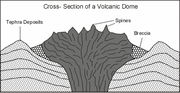
  • Lava  Domes or Volcanic Domes - result from the extrusion of highly viscous, gas poor andesitic and rhyolitic lava.  Since the viscosity is so high, the lava does not flow away from the vent, but instead piles up over the vent. Blocks of nearly solid lava break off the outer surface of the dome and roll down its flanks to form a breccia around the margins of domes.
The surface of volcanic domes are generally very rough, with numerous spines that have been pushed up by the magma from below.
volcdome.gif(16355 bytes)
Pyroclastic Material
If the magma has high gas content and high viscosity, the gas will expand in an explosive fashion and break the liquid into clots that fly through the air and cool along their path through the atmosphere.  Alternatively it blast out solid pieces of rock that once formed the volcanic edifice.  All of these fragments are referred to as Pyroclasts = hot, broken fragments. Loose assemblages of pyroclasts called tephra. Depending on size, tephra can be classified as bombs. blocks, lapilli, or ash.


Tephra and Pyroclastic Rocks
Average Particle Size (mm)Unconsolidated Material (Tephra)Pyroclastic Rock
>64Bombs or BlocksAgglomerate
2 - 64LapilliLapilli Tuff
<2AshAsh Tuff
  • Blocks are angular fragments that were solid when ejected.
  • Bombs have an aerodynamic shape indicating they were liquid when ejected.
  • Bombs and lapilli that consist mostly of gas bubbles (vesicles) result in a low density highly vesicular rock fragment called pumice.
Rock formed by accumulation and cementation of tephra called a pyroclastic rock or tuff. Welding, compaction and deposition of other grains cause tephra (loose material) to be converted into pyroclastic rock. 

 
Volcanic Landforms
Volcanic landforms are controlled by the geological processes that form them and act on them after they have formed. Thus, a given volcanic landform will be characteristic of the types of material it is made of, which in turn depends on the prior eruptive behavior of the volcano. Here we discuss the major volcanic landforms and how they are formed Most of this material will be discussed with reference to slides shown in class that illustrate the essential features of each volcanic landform.
  
Shield Volcanoes
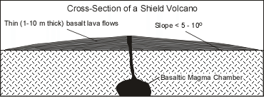
  • A shield volcano is characterized by gentle upper slopes (about 5o) and somewhat steeper lower slopes (about   10o).  
       
shieldvolc.gif (10889 bytes)
 
  • Shield volcanoes are composed almost entirely of relatively thin lava flows built up over a central vent.
  • Most shields were formed by low viscosity basaltic magma that flows easily down slope away from the summit vent. 
  • The low viscosity of the magma allows the lava to travel down slope on a gentle slope, but as it cools and its viscosity increases, its thickness builds up on the lower slopes giving a somewhat steeper lower slope.
  • Most shield volcanoes have a roughly circular or oval shape in map view.
  • Very little pyroclastic material is found within a shield volcano, except near the eruptive vents, where small amounts of pyroclastic material accumulate as a result of fire fountaining events. 

Stratovolcanoes (also called Composite Volcanoes)
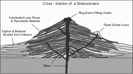
  • Have steeper slopes than shield volcanoes, with slopes of 6 to 10o low on the flanks to  30o near the top.
  • The steep slope near the summit is due partly to thick, short viscous lava flows that do not travel far down slope from the  vent.
stratovol.gif(37491 bytes)

  • The gentler slopes near the base are due to accumulations of material eroded from the volcano and to the accumulation of pyroclastic material.
  • Stratovolcanoes show inter-layering of lava flows and pyroclastic material, which is why they are sometimes called composite volcanoes.  Pyroclastic material can make up over 50% of the volume of a stratovolcano.
  • Lavas and pyroclastics are usually andesitic to rhyolitic in composition.
  • Due to the higher viscosity of magmas erupted from these volcanoes, they are usually more explosive than shield volcanoes.
  • Stratovolcanoes sometimes have a crater at the summit that is formed by explosive ejection of material from a central vent.  Sometimes the craters have been filled in by lava flows or lava domes, sometimes they are filled with glacial ice, and less commonly  they are filled with water.
  • Long periods of repose (times of inactivity) lasting for hundreds to thousands of years, make this type of volcano particularly dangerous, since many times they have shown no historic activity, and people are reluctant to heed warnings about possible eruptions.

Cinder Cones
  • Cinder cones are small volume cones consisting predominantly of ash and scoria that result from mildly explosive eruptions.  They usually consist of basaltic to andesitic material.
  • They are actually fall deposits that are built surrounding the eruptive vent.
  • Slopes of the cones are controlled by the angle of repose (angle of stable slope for loose unconsolidated material) and are usually between about 25 and 35o.
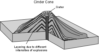
  • They show an internal layered structure due to varying intensities of the explosions that deposit different sizes of pyroclastics.
cindercone.gif(11375 bytes)
  • On young cones, a depression at the top of the cone, called a crater, is evident, and represents the area above the vent from which material was explosively ejected.  Craters are usually eroded away on older cones.
  • If lava flows are emitted from tephra cones, they are usually emitted from vents on the flank or near the base of the cone during the later stages of eruption.
  • Cinder and tephra cones usually occur around summit vents and flank vents of stratovolcanoes.
  • An excellent example of cinder cone is Parícutin Volcano in Mexico. This volcano was born in a farmers corn field in 1943 and erupted for the next 9 years.  Lava flows erupted from the base of the cone eventually covered two towns.
Craters and Calderas
  • Craters are circular depressions, usually less than 1 km in diameter, that form as a result of explosions that emit gases and ash.
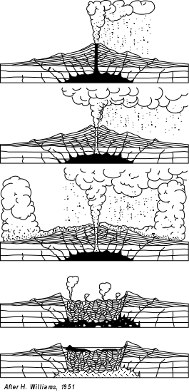
  • Calderas are much larger depressions, circular to elliptical in shape, with diameters ranging from 1 km to 50 km.  Calderas form as a result of collapse of a volcanic structure.  The collapse results from evacuation of the underlying magma chamber.
  • Crater Lake Caldera in southern Oregon is an 8 km diameter caldera containing a lake  The caldera formed about 6800 years ago as a result of the eruption of about 75 km3 of rhyolite magma in the form of tephra, found as far away as Canada, accompanied by pyroclastic flows that left thick deposits of tuff on the flanks of the volcano.  Subsequent eruptions have built a cinder cone on the floor of the caldera, which now forms an island called Wizard Island.
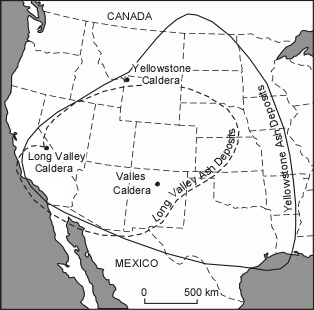
yellowstoneash.gif(21891 bytes)


  • In stratovolcanoes the collapse and formation of a caldera results from rapid evacuation of the underlying magma chamber by voluminous explosive eruptions that form extensive fall deposits and pyroclastic flows.
  • On shield volcanoes, like in Hawaii, the evacuation of the magma chamber is a slow drawn out processes, wherein  magma is withdrawn to erupt on from the rift zones on the flanks.
     
  • Larger calderas have formed within the past million years in the western United States.  These include Yellowstone Caldera in Wyoming, Long Valley Caldera in eastern California, and Valles Caldera in New Mexico.
  
  • The Yellowstone caldera is an important example, as it illustrates the amount of repose time that might be expected from large rhyolitic systems, and the devastating effect caldera forming eruptions can have on widespread areas.

    • Yellowstone Caldera which occupies most of Yellowstone National Park, is actually the third caldera to form in the area within the past 2 million years.  The three calderas formed at 2.0 million years ago, 1.3 million years ago, and the latest at 600,000 years ago.  Thus the repose time is on the average about 650,000 years.
    • Tephra fall deposits from the latest eruption are found in Louisiana and into the Gulf of Mexico, and covered much of the Western part of the United States.
    • The eruption 600,000 years ago produced about 1000 km3 of rhyolite (in comparison, the eruption of Mt. St. Helens in May of 1980 produced only 0.75 km3.
    • Magma still underlies Yellowstone caldera, as evidenced by the large number of hot springs and geysers in the area.
Volcanic Eruptions
In general, magmas that are generated deep within the Earth begin to rise because they are less dense than the surrounding solid rocks.  As they rise they may encounter a depth or pressure where the dissolved gas no longer can be held in solution in the magma, and the gas begins to form a separate phase (i.e. it makes bubbles just like in a bottle of carbonated beverage when the pressure is reduced).
When a gas bubble forms, it will also continue to grow in size as pressure is reduced and more of the gas comes out of solution.  In other words, the gas bubbles begin to expand. If the liquid part of the magma has a low viscosity, then the gas can expand relatively easily.  When the magma reaches the Earth's surface, the gas bubble will simply burst, the gas will easily expand to atmospheric pressure, and a effusive or non-explosive eruption will occur, usually as a lava flow
If the liquid part of the magma has a high viscosity, then the gas will not be able to expand very easily, and thus, pressure will build up inside of the gas bubble(s).  When this magma reaches the surface, the gas bubbles will have a high pressure inside, which will cause them to burst explosively on reaching atmospheric pressure.  This will cause an explosive volcanic eruption and the production of pyroclastic material.
Effusive Eruptions

Effusive or Non explosive eruptions are favored by low gas content and low viscosity magmas (basaltic to andesitic magmas).
  • If the viscosity is low, non-explosive eruptions usually begin with fire fountains due to release of dissolved gases.
  • Lava flows are produced on the surface, and these run like liquids down slope, along the lowest areas they can find.
  • If the magma emerges along a fracture, it results in a fissure eruption, often called a "curtain of fire"
  • Lava flows produced by eruptions under water are called pillow lavas.
  • If the viscosity is high, but the gas content is low, then the lava will pile up over the vent to produce a lava dome orvolcanic dome.
Explosive Eruptions
Explosive eruptions are favored by high gas content & high viscosity magmas (andesitic to rhyolitic magmas).  The explosive bursting of bubbles fragments the magma into clots of liquid that cool as they fall through the air. These solid particles become pyroclasts or volcanic ash.

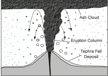
Clouds of gas and tephra that rise above a volcano produce aneruption column that can rise up to 45 km into the atmosphere. Eventually the tephra in the eruption column will be picked up by the wind, carried for some distance, and then fall back to the surface as a tephra fall orash fall.  This type of eruption is called a Plinian eruption.EruptColumn.GIF (17691 bytes)
If the pressure in the bubbles is low, the eruption will produce an eruption column only a few hundred meters high, and most of the pyroclastic material will fall to close to the vent to build a cinder cone.  This type of eruption is called a Strombolian eruption, and is considered mildly explosive.
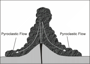
If the eruption column collapses a pyroclastic flow  will occur, wherein gas and tephra rush down the flanks of the volcano at high speed.  This is the most dangerous type of volcanic eruption.  The deposits that are produced are called ignimbritesif they contain pumice orpyroclastic flow deposits if they contain non-vesicular blocks.PyroclasFlow.GIF (12927 bytes)
A Plinian eruption and pyroclastic flow from Vesuvius volcano killed about 20,000 people in Pompeii in 79 CE.
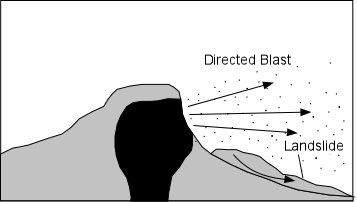
If the gas pressure inside the magma is directed outward instead of upward, a lateral blast can occur.  When this occurs on the flanks of a lava dome, a pyroclastic flows called a glowing avalanche or nuée ardentes (in French) can also result. Directed blasts often result from sudden exposure of the magma by a landslide or collapse of a lava dome.DirectBlast.GIF (7505 bytes)
This happened at Mt. Pelée Volcano in Martinique in 1902 and killed about 30,000 people.
Lahars (Volcanic Mudflows)
A volcanic eruption usually leaves lots of loose unconsolidated fragmental debris. When this loose material mixes with water from rainfall, melting of snow or ice, or draining of a crater lake, a mudflow results. Volcanic mudflows are called lahars.  These can occur accompanying an eruption or occur long after an eruption.  Lahars may be hot or cold and move at high velocity as they fill stream valleys that drain the volcano.   At the base of the volcano, they spread out and cover wide areas.  In general, they dev estate anything in their path, carrying away homes, buildings, bridges, and destroying roads, and killing livestock and people.
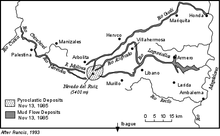
 In 1985 a lahar produced by a mild eruption of Nevado de Ruiz volcano in Colombia wiped out the village of Armero, about 60 km away from the volcano and killed about 23,000 people.
NRuiz.GIF (22507 bytes)
It is important to understand that lahars can occur accompanying an eruption, or can occur simply as the result of heavy rainfall or sudden snow melt, without an eruption.
Volcanic Gases
Although the predominant gas erupted from volcanoes is H2O vapor, other gases are erupted can have disastrous effects on life.   Poisonous gases like Hydrogen Chloride (HCl),  Hydrogen Sulfide (H2S), SO2, Hydrogen Fluoride (HF), and Carbon Dioxide (CO2).  The Chlorine, Sulfur. and Fluorine gases can kill organisms by direct ingestion, or by absorption onto plants followed by ingestion by organisms.  
In 1986 an CO2 gas emission from Lake Nyos in Cameroon killed more than 1700 people and 3000 cattle.
The gases can also have an effect on the atmosphere and climate.   Much of the water on the surface of the earth was produced by volcanoes throughout earth history.
LakeNyos.GIF (8328 bytes)
Sulfur gases in the atmosphere, along with volcanic ash, reflect incoming solar radiation back into space and have a cooling effect on the atmosphere, thus lowering average global temperatures.  The effect lasts only as long as the gases and ash remain in the atmosphere, normally a few years at the most.   CO2 gas, produces the opposite effect.  It is a greenhouse gas which absorbs solar radiation and causes a warming effect.   Eruptions in the past that produced huge quantities of this gas may have been responsible for mass extinction events  

The Eruption of Mount. St. Helens, 1980
Prior to 1980, Mount St. Helens last erupted in 1857.  On March 21, 1980 a 4.2 earthquake occurred beneath the volcano signaling the beginning of an eruption. Small eruptions took place through mid April and the summit of the mountain developed a new crater due to the explosions. By the end of April surveys showed that the north face of the mountain had begun to bulge upwards and outwards at rates up to 1 m per day.  By May 12, the bulge had displaced parts of the northern part of the volcano a distance of about 150 m.  Geologists now recognized that this bulge could soon develop into a landslide. 
At 8:32 AM on May 18, 1980 a magnitude 5.0 earthquake occurred beneath Mt. St. Helens.  This led to a violent eruption that took place over about the next minute.  The earthquake triggered a large landslide that began to slide out to the north, initially as three large blocks.
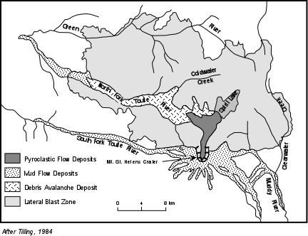
As the first block, began to slide downward, the magma chamber beneath the volcano became exposed to atmospheric pressure.   The gas inside the magma expanded rapidly, producing a lateral blast that moved outward toward the north.  As the second slide block began to move downwards a vertical eruption column began to form above the volcano.  The lateral blast rapidly overtook the slide block and roared through an area to the north of the mountain, knocking down all trees in its path and suffocating all living things,  Within the next 10 seconds the third slide block moved out toward the north.  The landslide thus became a debris avalanche and left a deposit extending about 20 km down the valley (see map below).  The southern shores of Spirit Lake were displaced about 1 km northward and the level of the lake was raised about 40 m.  StHelensEruptStages.GIF (26344 bytes)
Within about the first minute of the eruption the summit of Mount St. Helens had been reduced by about 500 m.  The magma however continued to erupt in a Plinian eruption column that reached up to 26 km into the atmosphere. StHelensMap.GIF (28927 bytes)
The eruption column collapsed several times to produce pyroclastic flows that moved into Spirit Lake and the upper reaches of the Toutle River Valley.  This Plinian phase lasted about 9 hours and spread tephra in a plume to the east, darkening the area at midday to make it appear like night.In all, 62 people lost their lives, either by being buried by the debris avalanche deposit, or suffocating by breathing the hot gases and dust of the blast.
Over the next several days melted snow combined with the new ash to produce lahars that roared down the North and South Forks of the Toutle River and drainages to the south of the volcano. 
In general, the eruption had been much larger than most anticipated, but the fact that a hazards study had been carried out, that public officials were quick to act and evacuate the danger zone, and that the volcano was under constant monitoring, resulted in the minimization of loss of life to only 62 instead of a much larger number that could have been killed had not these efforts been in place.Since the 1980 eruption, several volcanic domes have been emplaced in the crater and some have been blasted out.  In the future, it is expected that new domes will continue to form, eventually building the volcano back to a form that will look more like it did prior to the 1980 eruption.
Predicting Volcanic Eruptions
Before discussing how we can predict volcanic eruptions, its important to get some terminology straight by defining some commonly used terms.
Active Volcano - An active volcano to volcanologists is a volcano that has shown eruptive activity within recorded history.   Thus an active volcano need not be in eruption to be considered active. 
  • Currently there are about 600 volcanoes on Earth considered to be active volcanoes. 
  • Each year 50 to 60 of volcanoes actually erupt.
Extinct Volcano - An extinct volcano is a volcano that has not shown any historic activity, is usually deeply eroded, and shows no signs of recent activity.  How old must a volcano be to be considered extinct depends to a large degree on past activity.
Dormant Volcano - A dormant volcano (sleeping volcano) is somewhere between active and extinct.  A dormant volcano is one that has not shown eruptive activity within recorded history, but shows geologic evidence of activity within the geologic recent past. Because the lifetime of a volcano may be on the order of a million years, dormant volcanoes can become active volcanoes all of sudden.  These are perhaps the most dangerous volcanoes because people living in the vicinity of a dormant volcano may not understand the concept of geologic time, and there is no written record of activity.  These people are sometimes difficult to convince when a dormant volcano shows signs of renewed activity.
Long - Term Forecasting and Volcanic Hazards Studies  
  • Studies of the geologic history of a volcano are generally necessary to make an assessment of the types of hazards posed by the volcano and the frequency at which these types of hazards have occurred in the past.  The best way to determine the future behavior of a volcano is by studying its past behavior as revealed in the deposits produced by ancient eruptions.   Because volcanoes have such long lifetimes relative to human recorded history, geologic studies are absolutely essential.
  • Once this information is available, geologists can then make forecasts concerning what areas surrounding a volcano would be subject to the various kinds of activity should they occur in a future eruption, and also make forecasts about the long - term likelihood or probability of a volcanic eruption in the area.
     
  • During such studies, geologists examine sequences of layered deposits and lava flows.  Armed with knowledge about the characteristics of deposits left by various types of eruptions, the past behavior of a volcano can be determined.
  • Using radiometric age dating of the deposits the past frequency of events can be determined.
  • This information is then combined with knowledge about the present surface aspects of the volcano to make volcanic hazards maps which can aid other scientists, public officials, and the public at large to plan for evacuations, rescue and recovery in the event that short-term prediction suggests another eruption.
  • Such hazards maps delineate zones of danger expected from the hazards discussed above: lava flows, pyroclastic flows, tephra falls, lahars, floods, etc.
Short - Term Prediction based on Volcanic Monitoring
Short - term prediction of volcanic eruptions involves monitoring the volcano to determine when magma is approaching the surface and monitoring for precursor events that often signal a forthcoming eruption. 
  • Earthquakes - As magma moves toward the surface it usually deforms and fractures rock to generate earthquakes. Thus an increase in earthquake activity immediately below the volcano is usually a sign that an eruption will occur.  
  • Ground Deformation - As magma moves into a volcano, the structure may inflate.  This will cause deformation of the ground which can be monitored.  Instruments like tilt meters measure changes in the angle of the Earth's surface. Other instruments track changes in distance between several points on the ground to monitor deformation. 
  • Changes in Heat Flow - Heat is everywhere flowing out of the surface of the Earth.  As magma approaches the surface or as the temperature of groundwater increases, the amount of surface heat flow will increase.  Although these changes may be small they be measured using infrared remote sensing.
  • Changes in Gas Compositions - The composition of gases emitted from volcanic vents and fumaroles often changes just prior to an eruption. In general, increases in the proportions of hydrogen chloride (HCl) and sulfur dioxide (SO2) are seen to increase relative to the proportion of water vapor.
In general,  no single event can be used to predict a volcanic eruption, and thus many events are usually monitored so that taken in total, an eruption can often be predicted. Still,  each volcano behaves somewhat differently, and until patterns are recognized for an individual volcano, predictions vary in their reliability. Furthermore, sometimes a volcano can erupt with no precursor events at all.
Volcanic Hazards
The main types of volcanic hazards have been discussed above, so here we only briefly discuss them.  You should  make sure you understand what each of these are, and what effects each type of hazard can have. We will not likely have time to discuss these again in detail, so the following material is mostly for review.
Primary Effects of Volcanism
  • Lava Flows - lava flows are common in Hawaiian and Strombolian type of eruptions, the least explosive.  Although they have been known to travel as fast as 64 km/hr, most are slower and give people time to move out of the way. Thus, in general, lava flows are most damaging to property, as they can destroy anything in their path.
  • Pyroclastic Flows - Pyroclastic flows are one of the most dangerous aspects of volcanism.  They cause death by suffocation and burning.  They can travel so rapidly that few humans can escape.
  • Ash falls  - Although tephra falls blanket an area like snow, they are far more destructive because tephra deposits have a density more than twice that of snow and tephra deposits do not melt like snow an cause the collapse of roof. They and can affect areas far from the eruption. Tephra falls destroy vegetation, including crops, and can kill livestock that eat the ash covered vegetation.  Tephra falls can cause loss of agricultural activity for years after an eruption.
  • Poisonous Gas Emissions , as discussed above. 
Secondary and Tertiary Effects of Volcanism
  • Mudflows (Lahars) As discussed above, mudflows can both accompany an eruption and occur many years after an eruption.  They are formed when water and loose ash deposits come together and begin to flow.  The source of water can be derived by melting of snow or ice during the eruption, emptying of crater lakes during an eruption, or rainfall that takes place any time with no eruption. 
  • Debris Avalanches, Landslides, and Debris Flows - Volcanic mountains tend to become oversteepened as a result of the addition of new material over time as well due to inflation of the mountain as magma intrudes. Oversteepened slopes may become unstable, leading to a sudden slope failure that results in landslides, debris flows or debris avalanches.  Debris avalanches, landslides, and debris flows do not necessarily occur accompanied by a volcanic eruption.  There are documented cases of such occurrences where no new magma has been erupted.
  • Flooding - Drainage systems can become blocked by deposition of pyroclastic flows and lava flows.  Such blockage may create a temporary dam that could eventually fill with water and fail resulting in floods downstream from the natural dam. Volcanoes in cold climates can melt snow and glacial ice, rapidly releasing water into the drainage system and possibly causing floods. Jokaulhlaups occur when heating of a glacier results in rapid outburst of water from the melting glacier.
  • Tsunami - Debris avalanche events, landslides, caldera collapse events, and pyroclastic flows entering a body of water may generate tsunami. During the 1883 eruption of Krakatau volcano, in the straits of Sunda between Java and Sumatra, several tsunami were generated by pyroclastic flows entering the sea and by collapse accompanying caldera formation.  The tsunami killed about 36,400 people, some as far away from the volcano as 200 km.
  • Volcanic Earthquakes - Earthquakes usually precede and accompany volcanic eruptions, as magma intrudes and moves within the volcano. Although most volcanic earthquakes are small, some are large enough to cause damage in the area immediately surrounding the volcano, and some are large enough to trigger landslides and debris avalanches, such as in the case of Mount St. Helens.
  • Atmospheric Effects- Fined grained ash and sulfur gases expelled into the atmosphere reflect solar radiations and cause cooling of the atmosphere.  CO2released by volcanoes can cause warming of the atmosphere.

Volcanoes and Plate Tectonics
Global Distribution of Volcanoes
In the discussion we had on igneous rocks and how magmas form, we pointed out that since the upper parts of the Earth are solid, special conditions are necessary to form magmas. These special conditions do not exist everywhere beneath the surface, and thus volcanism does not occur everywhere.  If we look at the global distribution of volcanoes we see that volcanism occurs four principal settings.
 
  1. Along divergent plate boundaries, such as Oceanic Ridges or spreading centers.
  2. In areas of continental extension (that may become divergent plate boundaries in the future).
  3. Along converging plate boundaries where subduction is occurring.
  4. And, in areas called "hot spots" that are usually located in the interior of plates, away from the plate margins. 
Since we discussed this in the lecture on igneous rocks, we only briefly review this material here.
  • Diverging Plate Margins

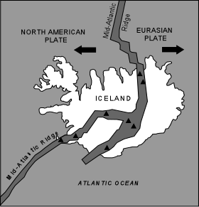
    Active volcanism is currently taking place along all of oceanic ridges, but most of this volcanism is submarine volcanism.  One place where an oceanic ridge reaches above sea level is at Iceland, along the Mid-Atlantic Ridge.  Here, most eruptions are basaltic in nature, but, many are explosive strombolian types or explosive phreatic or phreatomagmatic types.  As seen in the map to the right, the Mid-Atlantic ridge runs directly through Iceland

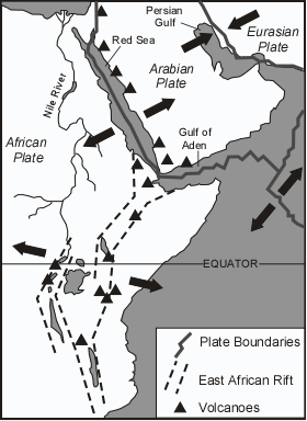
Volcanism also occurs in continental areas that are undergoing episodes of rifting.  A classic example is the East African Rift Valley, where the African plate is being split.  The extensional deformation occurs because the underlying mantle is rising from below and stretching the overlying continental crust. Upwelling mantle may melt to produce magmas, which then rise to the surface, often along normal faults produced by the extensional deformation.  Basaltic and rhyolitic volcanism is common in these areas.  In the same area, the crust has rifted apart along the Red Sea, and the Gulf of Aden to form new oceanic ridges.  This may also be the fate of the East African Rift Valley at some time in the future.
EAfrica.GIF (23625 bytes)

Other areas where extensional deformation is occurring within the crust is Basin and Range Province of the western U.S. (eastern California, Nevada, Utah, Idaho, western Wyoming and Arizona) and the Rio Grande Rift, New Mexico.  These are also areas of recent basaltic and rhyolitic volcanism.
  • Converging Plate Margins

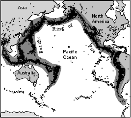
    All around the Pacific Ocean, is a zone often referred to as the Pacific Ring of Fire, where most of the world's most active and most dangerous volcanoes occur.  The Ring of Fire occurs because most of the margins of the Pacific ocean coincide with converging margins along which subduction is occurring
RingFire.GIF (23098 bytes)


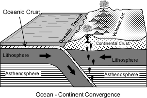
    The convergent boundary along the coasts of South America, Central America, Mexico, the northwestern U.S. (Northern California, Oregon, & Washington), western Canada,   and eastern Alaska, are boundaries along which oceanic lithosphere is being subducted beneath continental lithosphere.  This has resulted in the formation of continental volcanic arcs that form the Andes Mountains, the Central American Volcanic Belt, the Mexican Volcanic Belt, the Cascade Range, and the Alaskan volcanic arc.
OceanCont.GIF (13396 bytes)

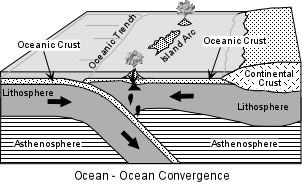
    The Aleutian Islands (west of Alaska), the Kurile-Kamchatka Arc, Japan, Philippine Islands, and Marianas Islands, New Zealand, and the Indonesian Islands, along the northern and western margins of the Pacific Ocean are zones where oceanic lithosphere is being subducted beneath oceanic lithosphere.  These are all island arcs.
oceanocean.gif(12446 bytes)

    • As discussed previously, the magmas are likely generated by flux melting of the mantle overlying the subduction zone to produce basaltic magmas. 
    • Through magmatic differentiation, basaltic magmas change to andesitic and rhyolitic magma.
    • Because these magmas are often gas rich and have all have relatively high viscosity, eruptions in these areas tend to be violent, with common Strombolian, Plinian and Pelean eruptions. 
    • Volcanic landforms tend to be cinder cones, stratovolcanoes, volcanic domes, and calderas. 
    • Repose periods between eruptions tend to be hundreds to thousands of years, thus giving people living near these volcanoes a false sense of security.
                
  • Hot Spots

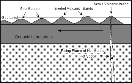
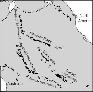
    Volcanism also occurs in areas that are not associated with plate boundaries, in the interior of plates.  These are most commonly associated with what is called a hot spot.  Hot spots appear to result from plumes of hot mantle material upwelling toward the surface, independent of the convection cells though to cause plate motion.  Hot spots tend to be fixed in position, with the plates moving over the top.  As the rising plume of hot mantle moves upward it begins to melt to produce magmas.  These magmas then rise to the surface producing a volcano.  But, as the plate carrying the volcano moves away from the position over the hot spot, volcanism ceases and new volcano forms in the position now over the hot spot. This tends to produce chains of volcanoes or seamounts (former volcanic islands that have eroded below sea level).
hotspot.gif(12121 bytes)


The Hawaiian Ridge is one such hot spot trace.  Here the Big Island of Hawaii is currently over the hot spot, the other Hawaiian islands still stand above sea level, but volcanism has ceased.  Northwest of the Hawaiian Islands, the volcanoes have eroded and are now seamounts.

LinearIslands.GIF (19512 bytes)

Plateau Basalts or Flood Basalts
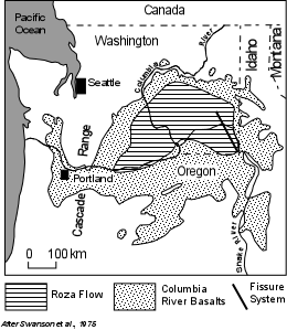
  • Plateau or Flood basalts are extremely large volume outpourings of low viscosity basaltic magma from fissure vents.  The basalts spread huge areas of relatively low slope and build up plateaus. 
  • Many of these outpourings appear to have occurred along a zone that eventually developed into a rift valley and later into a diverging plate boundary. 
  • In Oregon and Washington of the northwestern U.S., the Columbia River Basalts represent a series of lava flows all erupted within about 1 million years 12 million years ago.  One of the basalt flows, the Roza flow, was erupted over a period of a few weeks traveled about 300 km and has a volume of about 1500 km3.
FloodBasalts.GIF (19472 bytes)